Showing 73 items matching ballarat bitter
-
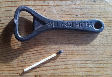 Hymettus Cottage & Garden
Bottle Opener, Ballarat Bitter Bottle Opener
... Ballarat Bitter Bottle Opener...Ballarat Bitter...Ballarat Bitter Ballarat Bitter Bottle Opener Bottle Opener ...Ballarat Bitter -
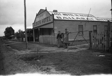 Ballarat Tramway Museum
Photograph - B&W print of donated negative, E G. Fluck, 17/06/1951 12:00:00 AM
... Ballarat Bitter... Bitter" on roof and on front "K.Sims / Late of Ballarat / Albion...tramways trams Lillimur Albion Hotel Ballarat Bitter Black ...Black and white print of a donated negative. Print made 8/1998. Photo of the Albion Hotel, Lillimur. Hotel has since been demolished. Has words "Last Hotel in Victoria / Ballarat Bitter" on roof and on front "K.Sims / Late of Ballarat / Albion Hotel" on front wall. Two people are standing by the side gate with the hotel in the background. Also has other buildings in the background of the town. Photo taken 17.6.51. High Res scan of copy negative added 17/1/2019 tramways, trams, lillimur, albion hotel, ballarat bitter -
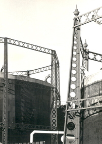 Federation University Historical Collection
Photograph - Photograph - Black and White, Geoff Biddington, Views of Ballarat, 1967
... ballarat bitter... orlando penfolds signwriting licensed grover ballarat bitter ...These images were taken by Geoff Biddington who was highly active in the Ballarat Branch of the National Trust. Twenty two black and white photographic views of Ballarat by Geoff Biddington. 1. Ballarat Mechanics' Institute 2. 18-20 Lyons Street south, Ballarat 3. Licensed grocer (Corner Eyre and Lyons Street South) featuring Ballarat Bertie Sign 4. Cast Iron Gasometer Frames 5. Former Ballarat Supreme Court (Ballarat School of Mines Electrical Engineering 6. Telegraph Station (Castlemaine?) 7. Ballarat Fine Art Gallery (later Art Gallery of Ballarat) 8. Former Ballarat Police Station, Camp Street 9. Former Baptist Church, Dawson Street 10. Craig's Hotel Lamp 11-13. Goller's, Camp Street 14. Old Post Box- Crown on Top 15. Former Ballarat Gaol Gates 16. Golden Point Football Club Rooms, Main Road 17. Ballarat Fire Station, Ballarat East 18. Ballarat Town Hall Tower 19. Ballan Hotel 20. Building on Inglis street, Ballan 21. Ballan News Building (Est 1872) 22. Adam Lindsay Gordon Cottagebiddington, ballarat mechanics' institute, ballaarat mechanics' institute, mechanics institute, gasometer, ballarat police station, police, baptist church, craig's hotel, goller, post box, crown, golden point, ballarat town hall, ballan hotel, adam lindsay gordon cottage, ballarat gaol gates, wrought iron, bluestone, ballarat bertie, orlando, penfolds, signwriting, licensed grover, ballarat bitter, craig's royal hotel lamp, craig's hotel -
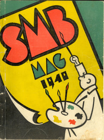 Federation University Historical Collection
Magazine - Booklet, Ballarat School of Mines Students' Magazine,1940
... ballarat bitter... gribbles crockers ballarat bitter modern dairy ballarat butter ...The Ballarat School of Mines was established in 1870. It is a predecessor institution of Federation University Australia.1. Soft covered, stapled magazine with yellow, red, green, black and white cover. 2. Soft covered, stapled magazine with yellow, red, green, black and white cover.The magazine has been signed by Shirly Bolan, Betty Delimo, Albert Stephen, Bessie Sargent, Sheila Moss, max coward, R. Rowlands, William Paterson, G. Wilson, D. Menhennet, Geoffrey Mounter, R. Monteirth, Maurice Collins, M. Hinch, G. Sutherland, Alan Kirsey, Joy Martin, Alan Gilpin, Colin Richardsballarat school of mines, ballarat gas company, owen's, tunbridge's, moss, gribbles, crockers, ballarat bitter, modern dairy, ballarat butter factory, middleton, literary society, boustead, sargeant, coward, martin, sheila moss, max coward -
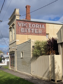 Ballarat Heritage Services
Photograph, Clare Gervasoni, Ballarat Building with Victoria Bitter Sign, 29/09/2021
... Ballarat Building with Victoria Bitter Sign... Bitter Sign Ballarat Building on the cover of Eyre Street ...Ballarat Building on the cover of Eyre Street and Lyons St South with Victoria Bitter Signvictoria bitter, ghost sign, lyons street south, eyre street, ballarat -
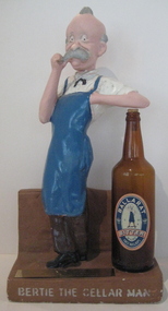 Federation University Historical Collection
Object, Ballarat Bertie, c1930s
... of Ballarat Bitter. Cast lettering on the base "Bertie the Cellarman... on a bottle of Ballarat Bitter. Cast lettering on the base "Bertie ...Ballarat Bertie was presented to lecturer Neville Gower by students of the first course in Brewing.Plaster model of Ballarat Bertie, leaning on a bottle of Ballarat Bitter. Cast lettering on the base "Bertie the Cellarman: On the underface of the base some eight signatures/na,es and with blue felt pen "Property of B.U.C. N. Gower"Brass Plate "Presented to Neville Gower on behalf of Malting and Brewing Class 1990"ballarat bertie, ballarat brewery, gower, neville gower, brewing, brewing and malting, ballarat university college. -
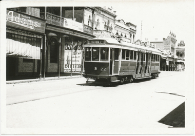 Ballarat Tramway Museum
Photograph - Digital image, Wal Jack, 25/12/1945 12:00:00 AM
... in the photograph. Also an ad for Ballarat Bitter. See image i2 for rear... for Ballarat Bitter. See image i2 for rear of photograph. See image ...Yields information about a bogie tram use when they first came to Ballarat in 1945 and the Bridge St streetscape.Digital image from the Wal Jack Ballarat Album of Ballarat 22 outbound in Bridge St for Victoria St, Christmas Day, 25-12-1945, photo Wal Jack. Has Herbert Adams, Reed Chemist and CTA Hotel in the background, note no other vehicles in the photograph. Also an ad for Ballarat Bitter. See image i2 for rear of photograph. See image i3 for hi res scan of print. See image i4 for hi res scan of negative Tex Morton died in 1983 and was a well known Country and Western performer. See Wikipedia and similar websites for more details.On rear in ink "SEC Ballarat #22 in Bridge St, Ballarat 25-12-1945". In top right hand corner is Wal Jack stamp with negative number "T88" written in.trams, tramways, bridge st, bogie trams, tram 22 -
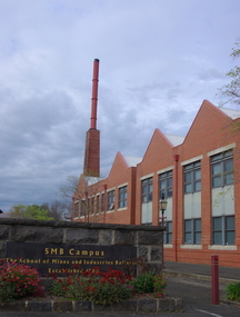 Federation University Historical Collection
Photograph (colour), Ballarat School of Mines Brewery Building, 06/10/2011
... successfully until 1994 on 'Ballarat Bitter' labels. During the1940s... successfully until 1994 on 'Ballarat Bitter' labels. During the1940s ...In 1872 William Tulloch and Alexander McLaren constructed a new brick 'Royal Standard Brewery' to the design of architect Henry R. Caselli. They had been operating a much smaller 'Royal Standard' Brewery, possibly since 1859. The Ballarat Brewing Company was established in 1895 and took over operations of the 'Royal Standard'. This new company resulted in the merger of the 'Royal Standard Brewery', James Coglans 'Phoenix Brewery' (Warrenheip) and Henry Leggo's 'Barley Sheaf Brewery' (Creswick Rd). J. Coglan and W. Tulloch were principals of the new company. By 1912 the Ballarat Brewery buildings fronting Armstrong Street were upgraded and new plant installed. Ballarat Brewing Company was well established as a thriving business. In 1926 'Ballarat Bertie' (the cellar-man) advertising image was introduced. It was used successfully until 1994 on 'Ballarat Bitter' labels. During the1940s and 50s the Ballarat Brewing Company was significantly upgraded and extended equipment and buildings. In 1959 Carlton and United Breweries purchased the Ballarat Brewery, its brewing rights and the land (but not the 114 BBC hotels or the Dana Street offices). The Lydiard Street frontage become the 'front' of the CUB Brewery. CUB ceased brewing at the Ballarat Brewery site in 1989 and closed the plant. Four years later the 'brewery site' was purchased by the Ballarat School of Mines to enlarge its campus area as TAFE was a rapidly expanding areas of education. In 1994 plans were developed for the 'Brewery Complex' with careful regard for needed educational facilities and due concern regarding historical aspects of the site and its buildings. There was close consultation and cooperation with the Ballarat City Council during the planning process. In 1995 most of the Brewery buildings were demolished by some special structures and features are preserved. The old brewery chimney was retained as a permanent reminder of the original industrial site, as were two boilers. The SMB Brewery Complex was completed in 1996 and reflects aspects of the former brewery's appearance. It was opened by Prime Minister John Howard on 28 February 1997. Further details at http://guerin.ballarat.edu.au/curator/buildings/site_listing_brewery-complex.shtml Twenty five colour photographs of the Brewery Building at the University of Ballarat SMB (Ballarat School of Mines) campus. The Brewery Building is built on the site of the former Ballarat Brewery and incorporates the chimney and 'Cowley' boilers from that site. ballarat school of mines, henry richards caselli, henry caselli, ballarat brewing, brewery, beer, cowleys foundry, carlton and united breweries -
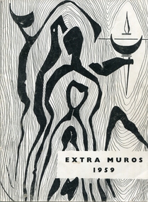 Federation University Historical Collection
Booklet - Magazine, J.A. Hoskin & Son, Extra Muros, 1959
The Publications Committee were Ken McDougall, Kath Hayes, Brian Haig, Sue Tucker, heather Bell, Dawn Brown, Ian george, elizabeth Lemmon, Janette Leviston, Leah Harwood, Tony scanlon. Mal Wordsworth. Ian Walshe. The Year Book Committee were Carmel Keys, Judy Krahe, Jill Mayo, and Mr Ryan was the staff representative. The Students' representative council for 1959 were J. O'Neill, I. Ferguson, I. Jenkins, E.Davies, B. Matthews, M. Robinson, R. Cummings, B. Vandenberg, N. Wright, D. McKimmie, K. McDougall, D. Eldridge, N. Beacham, K. Ryrie, J. Rae and D. Wise. The social committee comprised R. Power, G. Briggs, D. Ryan, G. Wallace, V. Delbridge, S. Dawe, Miss Lloyd, Mr Bourke, R. Kelly, M. Grey, J. Cadzow, E. Davies, Monica Miller, G. Commons and F. Mason. A black and white soft covered magazine of the Ballarat Teachers' College. The cover design was by Doug Sheen. Articles include: education in North Borneo, Webster St Hostel, Gillies Street Girls Hostel, Victoria Street Hostel, Camp Street Hostel, Gillies Street Boys Hostel, Ex-Students' association, The Joys of caravaning, How to Spend One's Leisure, Ideas from the Design Club, Faces Behind the Wheel, Life's Bitterness, Characterization, Such is Life. ballarat teachers' college, margaret brown, ken mcdougall, kath hayes, brian haig, tom turner, k. mcdougall, noel beacham, norma mchenry, heather speedie, ted doney, north borneo, webster street hostel, victoria street hostel, students residences, . o'neill, i. ferguson, i. jenkins, e.davies, b. matthews, m. robinson, r. cummings, b. vandenberg, n. wright, d. mckimmie, d. eldridge, n. beacham, k. ryrie, j. rae, d. wise, r. power, g. briggs, d. ryan, g. wallace, v. delbridge, s. dawe, miss lloyd, mr bourke, r. kelly, m. grey, j. cadzow, e. davies, monica miller, g. commons, f. mason, camp street hostel, gillies street hostel -
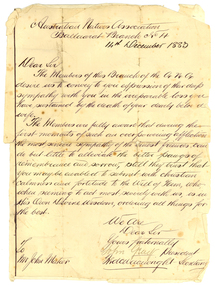 Federation University Historical Collection
Correspondence, John Gray, Letter of Condolence from ANA to John Mateer. 1883, 14/12/1883
The Australian Natives Association (ANA) Benefit Society was formed in 1871 at a meeting of young men in Grimwood's Hotel, Elizabeth Street, Melbourne. The Association was one of many friendly societies that also aimed to promote the moral, social and intellectual advancement of its members. The young founders restricted membership to native-born Australians, but there were no Koories among them. The Australian Natives Association Ballarat Branch (No4) was founded in 1874. The association’s modest building was based in Camp Street and the branch was one of the most active in the colony, playing a key role in Federation. The Ballarat branch of the ANA was wound up in 1957 and the double storey building has since been used as for office space most recently for employment companies such as Tracey Recruitment. Ballarat's ANA Hall has heritage status under the City of Ballarat’s Camp Street heritage overlay HO186, however it is not listed by either the Victorian Heritage Register or the National Trust.Handwritten letter glued onto a lined page. The letter is from the Australian Natives Association Ballarat Branch No. 4, and is written to John Mateer at the time of his wife's death. The letter is signed by John Gray (President) and Fred Wainwright (secretary). Fred Wainwright was the first secretary of ANA branch No. 4. hew as a clerk at Ballarat Town Hall, and presented an essay on Federation of Australian Colonies in 1879.Australian Natives Association Ballaarat Branch No 4 14th December 1883. Dear Sir The members of this branch of the A.N.A. desire us to convey to you expression of their deep sympanth with you in the irreparable loss you have sustained by the death of your dearly beloved wife. The Members are fully aware that during the first month of such an overpowering infliction the most sincere sympathy of the truest friends can do little by alleviate the bitter pangs of remembrance and sorrow, still they trust that you may be enabled to submit with christian calmness and fortitude to the Will of Him, who, when seeming to act most severely wit us, is in His Own Divine Wisdom, ordering things for the best. We are Dear Sir Yours fraternally John Gray President fred Wainwright Secretary To Mr John Mateer australian natives' association, ana, ballarat branch no. 4. ballaarat branch no. 4, gray, john gray, wainwright, fred wainwright, mateer, john mateer -
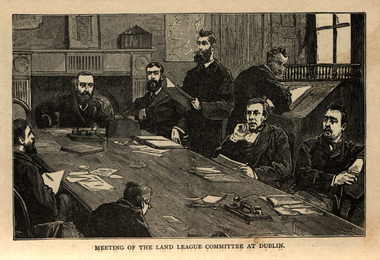 Ballarat and District Irish Association
Image, Land League Committee Meeting, Dublin, 1864
The Irish National Land League (Irish: Conradh na Talún) was an Irish political organisation of the late 19th century which sought to help poor tenant farmers. Its primary aim was to abolish landlordism in Ireland and enable tenant farmers to own the land they worked on. The period of the Land League's agitation is known as the Land War. Within decades of the league's foundation, through the efforts of William O'Brien and George Wyndham (a descendant of Lord Edward FitzGerald), the 1902 Land Conference produced the Land (Purchase) Act 1903 which allowed Irish tenant farmers buy out their freeholds with UK government loans over 68 years through the Land Commission (an arrangement that has never been possible in Britain itself). For agricultural labourers, D.D. Sheehan and the Irish Land and Labour Association secured their demands from the Liberal government elected in 1905 to pass the Labourers (Ireland) Act 1906, and the Labourers (Ireland) Act 1911, which paid County Councils to build over 40,000 new rural cottages, each on an acre of land. By 1914, 75% of occupiers were buying out their landlords, mostly under the two Acts. In all, under the pre-UK Land Acts over 316,000 tenants purchased their holdings amounting to 15 million acres (61,000 km2) out of a total of 20 million acres (81,000 km2) in the country. Sometimes the holdings were described as "uneconomic", but the overall sense of social justice was undeniable. (http://en.wikipedia.org/wiki/Irish_National_Land_League, accessed 21 January 2014) The Irish National Land League was founded at the Imperial Hotel in Castlebar, the County town of Mayo, on 21 October 1879. At that meeting Charles Stewart Parnell was elected president of the league. Andrew Kettle, Michael Davitt, and Thomas Brennan were appointed as honorary secretaries. This united practically all the different strands of land agitation and tenant rights movements under a single organisation. The two aims of the Land League, as stated in the resolutions adopted in the meeting, were: ...first, to bring out a reduction of rack-rents; second, to facilitate the obtaining of the ownership of the soil by the occupiers. That the object of the League can be best attained by promoting organisation among the tenant-farmers; by defending those who may be threatened with eviction for refusing to pay unjust rents; by facilitating the working of the Bright clauses of the Irish Land Act during the winter; and by obtaining such reforms in the laws relating to land as will enable every tenant to become owner of his holding by paying a fair rent for a limited number of years. Charles Stewart Parnell, John Dillon, Michael Davitt, and others including Cal Lynn then went to America to raise funds for the League with spectacular results. Branches were also set up in Scotland, where the Crofters Party imitated the League and secured a reforming Act in 1886. The government had introduced the first ineffective Land Act in 1870, then the equally inadequate Acts of 1880 and 1881 followed. These established a Land Commission that started to reduce some rents. Parnell together with all of his party lieutenants, including Father Eugene Sheehy known as "the Land League priest", went into a bitter verbal offensive and were imprisoned in October 1881 under the Irish Coercion Act in Kilmainham Jail for "sabotaging the Land Act", from where the No-Rent Manifesto was issued, calling for a national tenant farmer rent strike which was partially followed. Although the League discouraged violence, agrarian crimes increased widely. Typically a rent strike would be followed by evictions by the police, or those tenants paying rent would be subject to a local boycott by League members. Where cases went to court, witnesses would change their stories, resulting in an unworkable legal system. This in turn led on to stronger criminal laws being passed that were described by the League as "Coercion Acts". The bitterness that developed helped Parnell later in his Home Rule campaign. Davitt's views were much more extreme, seeking to nationalise all land, as seen in his famous slogan: "The land of Ireland for the people of Ireland". Parnell aimed to harness the emotive element, but he and his party preferred for tenant farmers to become freeholders on the land they rented, instead of land being vested in "the people".(http://en.wikipedia.org/wiki/Irish_National_Land_League, accessed 21 January 2014)Image of a number of men sitting around a table. They are members of the Land League Committee during a meeting in Dublin.ballarat irish, land league, land league committee, dublin -
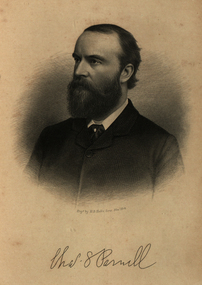 Ballarat and District Irish Association
Image, Charles Parnell, c1864, 1864
Parnell was an Irish nationalist and statesman who led the fight for Irish Home Rule in the 1880s. Charles Stewart Parnell was born on 27 June 1846 in County Wicklow into a family of Anglo-Irish Protestant landowners. He studied at Cambridge University and was elected to parliament in 1875 as a member of the Home Rule League (later re-named by Parnell the Irish Parliamentary Party). His abilities soon became evident. In 1878, Parnell became an active opponent of the Irish land laws, believing their reform should be the first step on the road to Home Rule. In 1879, Parnell was elected president of the newly founded National Land League and the following year he visited the United States to gain both funds and support for land reform. In the 1880 election, he supported the Liberal leader William Gladstone, but when Gladstone's Land Act of 1881 fell short of expectations, he joined the opposition. By now he had become the accepted leader of the Irish nationalist movement. Parnell now encouraged boycott as a means of influencing landlords and land agents, and as a result he was sent to jail and the Land League was suppressed. From Kilmainham prison he called on Irish peasants to stop paying rent. In March 1882, he negotiated an agreement with Gladstone - the Kilmainham Treaty - in which he urged his followers to avoid violence. But this peaceful policy was severely challenged by the murder in May 1882 of two senior British officials in Phoenix Park in Dublin by members of an Irish terrorist group. Parnell condemned the murders. In 1886, Parnell joined with the Liberals to defeat Lord Salisbury's Conservative government. Gladstone became prime minister and introduced the first Irish Home Rule Bill. Parnell believed it was flawed but said he was prepared to vote for it. The Bill split the Liberal Party and was defeated in the House of Commons. Gladstone's government fell soon afterwards.(http://www.bbc.co.uk/history/historic_figures/parnell_charles.shtml, accessed 21 January 2014) The Irish National Land League (Irish: Conradh na Talún) was an Irish political organisation of the late 19th century which sought to help poor tenant farmers. Its primary aim was to abolish landlordism in Ireland and enable tenant farmers to own the land they worked on. The period of the Land League's agitation is known as the Land War. Within decades of the league's foundation, through the efforts of William O'Brien and George Wyndham (a descendant of Lord Edward FitzGerald), the 1902 Land Conference produced the Land (Purchase) Act 1903 which allowed Irish tenant farmers buy out their freeholds with UK government loans over 68 years through the Land Commission (an arrangement that has never been possible in Britain itself). For agricultural labourers, D.D. Sheehan and the Irish Land and Labour Association secured their demands from the Liberal government elected in 1905 to pass the Labourers (Ireland) Act 1906, and the Labourers (Ireland) Act 1911, which paid County Councils to build over 40,000 new rural cottages, each on an acre of land. By 1914, 75% of occupiers were buying out their landlords, mostly under the two Acts. In all, under the pre-UK Land Acts over 316,000 tenants purchased their holdings amounting to 15 million acres (61,000 km2) out of a total of 20 million acres (81,000 km2) in the country. Sometimes the holdings were described as "uneconomic", but the overall sense of social justice was undeniable. (http://en.wikipedia.org/wiki/Irish_National_Land_League, accessed 21 January 2014) The Irish National Land League was founded at the Imperial Hotel in Castlebar, the County town of Mayo, on 21 October 1879. At that meeting Charles Stewart Parnell was elected president of the league. Andrew Kettle, Michael Davitt, and Thomas Brennan were appointed as honorary secretaries. This united practically all the different strands of land agitation and tenant rights movements under a single organisation. The two aims of the Land League, as stated in the resolutions adopted in the meeting, were: ...first, to bring out a reduction of rack-rents; second, to facilitate the obtaining of the ownership of the soil by the occupiers. That the object of the League can be best attained by promoting organisation among the tenant-farmers; by defending those who may be threatened with eviction for refusing to pay unjust rents; by facilitating the working of the Bright clauses of the Irish Land Act during the winter; and by obtaining such reforms in the laws relating to land as will enable every tenant to become owner of his holding by paying a fair rent for a limited number of years. Charles Stewart Parnell, John Dillon, Michael Davitt, and others including Cal Lynn then went to America to raise funds for the League with spectacular results. Branches were also set up in Scotland, where the Crofters Party imitated the League and secured a reforming Act in 1886. The government had introduced the first ineffective Land Act in 1870, then the equally inadequate Acts of 1880 and 1881 followed. These established a Land Commission that started to reduce some rents. Parnell together with all of his party lieutenants, including Father Eugene Sheehy known as "the Land League priest", went into a bitter verbal offensive and were imprisoned in October 1881 under the Irish Coercion Act in Kilmainham Jail for "sabotaging the Land Act", from where the No-Rent Manifesto was issued, calling for a national tenant farmer rent strike which was partially followed. Although the League discouraged violence, agrarian crimes increased widely. Typically a rent strike would be followed by evictions by the police, or those tenants paying rent would be subject to a local boycott by League members. Where cases went to court, witnesses would change their stories, resulting in an unworkable legal system. This in turn led on to stronger criminal laws being passed that were described by the League as "Coercion Acts". The bitterness that developed helped Parnell later in his Home Rule campaign. Davitt's views were much more extreme, seeking to nationalise all land, as seen in his famous slogan: "The land of Ireland for the people of Ireland". Parnell aimed to harness the emotive element, but he and his party preferred for tenant farmers to become freeholders on the land they rented, instead of land being vested in "the people".(http://en.wikipedia.org/wiki/Irish_National_Land_League, accessed 21 January 2014)Image of bearded man known as Charles Stewart Parnellballarat irish, parnell, charles parnell, home rule -
 Ballarat RSL Sub-Branch Inc.
Beer Cans
Toohey's Blue Label Bitter (1 of 2) Salute Second World War - Navycollectables, ballarat rsl, ballarat -
 Ballarat RSL Sub-Branch Inc.
Beer Can
Toohey's Blue Label Bitter (2 of 2) Salute Second World War - Navycollectables, ballarat rsl, ballarat -
 Ballarat RSL Sub-Branch Inc.
Beer Can
Toohey's Blue Label Bitter (1 of 2) Salute Second World War - RAAFcollectables, ballarat rsl, ballarat -
 Ballarat RSL Sub-Branch Inc.
Beer Can
Toohey's Blue Label Bitter (2 of 2) Salute Second World War - Navycollectables, ballarat rsl, ballarat -
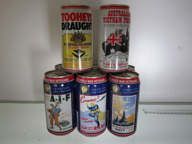 Ballarat RSL Sub-Branch Inc.
Beer Can
Toohey's Blue Label Bitter (1 of 2) Salute Second World War - AIFcollectables, ballarat rsl, ballarat -
 Ballarat RSL Sub-Branch Inc.
Beer Can
Toohey's Blue Label Bitter (2 of 2) Salute Second World War - AIFcollectables, ballarat rsl, ballarat -
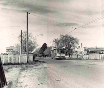 Ballarat Tramway Museum
Photograph - Black and White photograph/s - mounted set of 2', John Phillips, late 1960's or early 1970's
Yields information about the vicinity of the Victoria St terminus and the bridge over the Buninyong Railway line.Black and White photograph mounted on heavy cardboard backing. Photo of Ballarat No. 31, just after leaving Victoria St. terminus, late 1960's or early 1970s crossing over the Eureka siding railway bridge. Taken by John Phillips. Tram has destination of Gardens via Sturt St. West, Twin Lakes advertisement on the front. In the background is Meagher's Hotel with Abbots Lager and Victoria Bitter sign. On the bridge is graffiti "Smash US Imperialism". On the Ballarat side of the bridge is a sign directing travellers to the "Eureka Caravan Park". Has 6 Velcro dots on rear and marks where mounting devices have been removed on the rear. Note image scanned in two runs through a scanner, resulting in the shading in the image file. .1 - Second copy with 4 black Velcro squares and 4 dots on rear - wider view on the right hand side with an additional pole - not scanned.trams, tramways, victoria st, eureka, twin lakes, tram 31 -
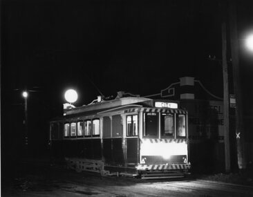 Ballarat Tramway Museum
Photograph - Black & White Photograph/s, Chris Wurr, 1971
Yields information about the streetscape and the trams at night outside the Royal Mail Hotel Sebastopol, the tram terminus.Black and White photograph of a single trucker (No. 21 - five windows) at the Sebastopol terminus, Albert St, outside the Royal Mail Hotel, just prior to the changeover from trams to buses. The tram has the destination of City. The pole with the tram stop signage is behind the tram while the new? bus stop sign is on the pole adjacent to the tram. Note that the pole has been condemned by the SEC. In the background is the hotel, with Melbourne Bitter and Fosters Larger advertised on the wall.Stamped on rear in black ink "Donated to BTPS by and Photo By" / "Chris Wurr 12 Truscott Street, Ararat 3377 (053) 52 3403.tramways, trams, sebastopol, albert st, tram 21 -
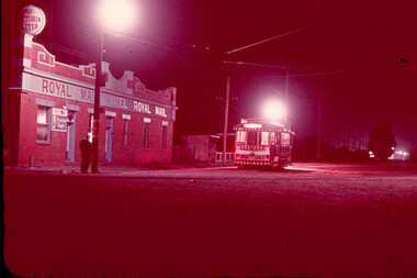 Ballarat Tramway Museum
Slide - 35mm slide/s, Dave Macartney, Apr. 1968
White cardboard mount, 35mm slide, from the Association of Railway Enthusiast's film strip titled "Provincial Tramway Film Strip" of No. 14 alongside the Royal Mail Hotel, Sebastopol. Night photo. Tram has a "Twin Lakes" sign and the hotel a "Victoria Bitter" sign. The film strip notes (Reg. Item 2560), provided the following caption details: "The doors of the ROYAL MAIL have long since closed for the night, whilst No. 14 waits to return from an almost deserted Sebastopol terminus. - Apr. '68 (Dave Macartney)" See image btm2578p.tif for high level scan of image. Stamped on base of slide "11788" and written in ink on top edge "No. 14 Sebastopol Ballarat"tramways, trams, are, film strip, albert st, sebastopol, royal mail hotel, tram 14 -
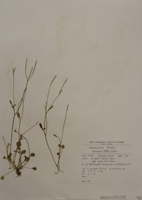 Federation University Herbarium
Plant specimen, Alexander Clifford Beauglehole, Cardamine hirsuta L, 23/10/1978
Cliff Beauglehole was an orchardist at Portland, Victoria, who throughout hislife took an intense interest in the plants of Victoria. Over his lifetime he collected 90,000 plant specimens as part of a comprehensive study of Victoria's plants and wrote thirteen books under the heading The Distribution and Conservation of Vascular Plants in Victoria, each written to cover the 13 study areas of the Victorian and Conservation Council.A mounted botanical specimen.beauglehole herbarium, herbarium specimen, botany, herbarium, plant science, plant specimen, field naturalists' club ballarat, federation university herbarium, cardamine hirsuta, common bitter-cress, brassicaceae -
 Ballarat Heritage Services
Photograph - Colour, Masons' Marks, Old Sarum, England, English Heritage Site, 01 November 2016
William the Conqueror inherited Old Sarum from the last Saxon king of England. It was an ideal site for a royal castle. It was here in 1070 that William paid off his army after a long and bitter campaign in northern England. It was here in 1086 that he called together all the major landholders in England so they could swear allegiance to him. It was a crucial moment. The Domesday Book was being written, a threatened Viking invasion had only just been averted and William's eldest son was in armed rebellion. Old Sarum was an important place where this Norman king of England held power. In 1794 the Ordnance Survey set out to check the accuracy of the first mapping of Southern England, which had begun ten years earlier. From a point just below Old Sarum Lieutenant William Mudge laid out a base-line 36,574 feet (11,253 metres) long. From each end of the line the positions of distant places were plotted using a huge theodolite made in 1791 by Jesse Ramsden. The accuracy of the process, which was repeated all over England, depended on Jesse Ramsden's craftsmanship and on William Mudge's surveying skill in setting out this first base-line from Old Sarum. The nearer end of Mudge's line is marked by an inscribed stone beside the modern A345 at Old Sarum. ordnance survey, william mudge, jesse ramsden, william the conqueror, old sarum, saxon, 1086, england -
 Ballarat Heritage Services
Photograph - Colour, Masons' Marks, Old Sarum, England, English Heritage Site, 2016, 01 November 2016
William the Conqueror inherited Old Sarum from the last Saxon king of England. It was an ideal site for a royal castle. It was here in 1070 that William paid off his army after a long and bitter campaign in northern England. It was here in 1086 that he called together all the major landholders in England so they could swear allegiance to him. It was a crucial moment. The Domesday Book was being written, a threatened Viking invasion had only just been averted and William's eldest son was in armed rebellion. Old Sarum was an important place where this Norman king of England held power. In 1794 the Ordnance Survey set out to check the accuracy of the first mapping of Southern England, which had begun ten years earlier. From a point just below Old Sarum Lieutenant William Mudge laid out a base-line 36,574 feet (11,253 metres) long. From each end of the line the positions of distant places were plotted using a huge theodolite made in 1791 by Jesse Ramsden. The accuracy of the process, which was repeated all over England, depended on Jesse Ramsden's craftsmanship and on William Mudge's surveying skill in setting out this first base-line from Old Sarum. The nearer end of Mudge's line is marked by an inscribed stone beside the modern A345 at Old Sarum. ordnance survey, william mudge, jesse ramsden, william the conqueror, old sarum, saxon, 1086, england -
 Ballarat Heritage Services
Photograph - Colour, Earth Banks, Old Sarum, England, 2016, 01 November 2016
William the Conqueror inherited Old Sarum from the last Saxon king of England. It was an ideal site for a royal castle. It was here in 1070 that William paid off his army after a long and bitter campaign in northern England. It was here in 1086 that he called together all the major landholders in England so they could swear allegiance to him. It was a crucial moment. The Domesday Book was being written, a threatened Viking invasion had only just been averted and William's eldest son was in armed rebellion. Old Sarum was an important place where this Norman king of England held power. In 1794 the Ordnance Survey set out to check the accuracy of the first mapping of Southern England, which had begun ten years earlier. From a point just below Old Sarum Lieutenant William Mudge laid out a base-line 36,574 feet (11,253 metres) long. From each end of the line the positions of distant places were plotted using a huge theodolite made in 1791 by Jesse Ramsden. The accuracy of the process, which was repeated all over England, depended on Jesse Ramsden's craftsmanship and on William Mudge's surveying skill in setting out this first base-line from Old Sarum. The nearer end of Mudge's line is marked by an inscribed stone beside the modern A345 at Old Sarum. ordnance survey, william mudge, jesse ramsden, william the conqueror, old sarum, saxon, 1086, england -
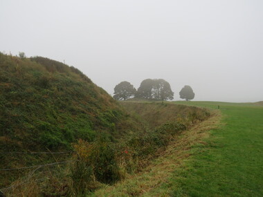 Ballarat Heritage Services
Photograph - Colour, Earth Banks, Old Sarum, England, 01 November 2016
William the Conqueror inherited Old Sarum from the last Saxon king of England. It was an ideal site for a royal castle. It was here in 1070 that William paid off his army after a long and bitter campaign in northern England. It was here in 1086 that he called together all the major landholders in England so they could swear allegiance to him. It was a crucial moment. The Domesday Book was being written, a threatened Viking invasion had only just been averted and William's eldest son was in armed rebellion. Old Sarum was an important place where this Norman king of England held power. In 1794 the Ordnance Survey set out to check the accuracy of the first mapping of Southern England, which had begun ten years earlier. From a point just below Old Sarum Lieutenant William Mudge laid out a base-line 36,574 feet (11,253 metres) long. From each end of the line the positions of distant places were plotted using a huge theodolite made in 1791 by Jesse Ramsden. The accuracy of the process, which was repeated all over England, depended on Jesse Ramsden's craftsmanship and on William Mudge's surveying skill in setting out this first base-line from Old Sarum. The nearer end of Mudge's line is marked by an inscribed stone beside the modern A345 at Old Sarum. ordnance survey, william mudge, jesse ramsden, william the conqueror, old sarum, saxon, 1086, england -
 Ballarat Heritage Services
Photograph - Colour, Earth Banks, Old Sarum, England, 2016, 01 November 2016
William the Conqueror inherited Old Sarum from the last Saxon king of England. It was an ideal site for a royal castle. It was here in 1070 that William paid off his army after a long and bitter campaign in northern England. It was here in 1086 that he called together all the major landholders in England so they could swear allegiance to him. It was a crucial moment. The Domesday Book was being written, a threatened Viking invasion had only just been averted and William's eldest son was in armed rebellion. Old Sarum was an important place where this Norman king of England held power. In 1794 the Ordnance Survey set out to check the accuracy of the first mapping of Southern England, which had begun ten years earlier. From a point just below Old Sarum Lieutenant William Mudge laid out a base-line 36,574 feet (11,253 metres) long. From each end of the line the positions of distant places were plotted using a huge theodolite made in 1791 by Jesse Ramsden. The accuracy of the process, which was repeated all over England, depended on Jesse Ramsden's craftsmanship and on William Mudge's surveying skill in setting out this first base-line from Old Sarum. The nearer end of Mudge's line is marked by an inscribed stone beside the modern A345 at Old Sarum. ordnance survey, william mudge, jesse ramsden, william the conqueror, old sarum, saxon, 1086, england